PART I
OBJECTIVE – TYPE QUESTIONS
1. The most destructive form of soil erosion is
A. rill
B. sheet
C. gulley
D. splash
2. Which of following rocks is commonly found at the coast of East Africa?
A. Granite
B. Limestone
C. Pumice
D. Marble
3.The youthful stage of a river profile is characterized by
A. interlocking spurs
B. flood plains
C. ox-bow lakes
D. meanders
4. Which one of the following is a metamorphic rock?
A. Clay
B. Mudstone
C. Sandstone
D. Gneiss
5.Beaches at Malindi along the coast of East Africa are important for
A. fishing
B. tourism
C. settlement
D. research centres
6. Which of the following mountains in East Africa is a block mountain?
A. Elgon
B. Moroto
C. Muhavura
D. Rwenzori
7. The Miombo woodland area of Tanzania is sparsely populated mainly because of
A. tsetse flies
B. poor thin soils
C. unreliable rainfall
D. remoteness
8. Which of the following is an example of a lava dammed lake in East Africa?
A. Turkana
B. Tanganyika
C. Mbuto
D. Mutanda
9. The distribution of population in East Africa is most closely related to differences in
A. rainfall
B. soil fertility
C. altitude
D. vegetation cover
10. In East Africa, temperature difference are mainly caused by
A. aspect
B. latitude
C. cloud cover
D. altitude
11. Which of the following is the main effect of mining of diamonds on the environment in Tanzania?
A. Landslides
B. Air pollution
C. Loss of vegetation cover
D. Creation of deep pits
12. The lines on map which join places with the same rainfall amounts are called
A. isotherms
B. isohyets
C. isobars
D. isohels
13. The major contribution of ranching schemes to the development of the livestock industry in East Africa is
A. growth of infrastructure
B. provision of extension services
C. increased supply of animal products
D. provision of employment opportunities
14. Which one of the following towns in East Africa has an oil refinery?
A. Nairobi
B. Jinja
C. Arusha
D. Dar-es-salaam
15. Tea growing in Kabarole district has been mainly favored by
A. availability of cheap labor
B. heavy reliable rainfall
C. well drained soils
D. well-developed transport
16. Which of the following fish species in East Africa is caught from swamps?
A. Tilapia
B. Mud fish
C. Dagaa
D. Nile perch
17. The major problem faced by sisal growers in Tanzania is the
A. loss of soil fertility
B. price fluctuations
C. shortage of land
D. competition from artificial fibres
18. The Pemba islands are known for the growing of
A. sugar cane
B. maize
C. cloves
D. tea
19. Which of the following factors favored the growth of Magadi town?
A. Presence of minerals
B. Favorable climate
C. Fertile soils
D. Good transport network
20. The major factor limiting the commercial mining of gold in Karamoja is
A. poor technology
B. shortage of skilled labor
C. limited gold reserves
D. poorly developed road network
21. The main problem facing the development of small-scale industries in Uganda is
A. inadequate raw materials
B. shortage of capital
C. limited market
D. high cost of power
22. Which type of vegetation in East Africa has trees with large buttress roots?
A. Tropical rain forest
B. Savanna grassland
C. Semi-deset scrub
D. Health and moorland
23. The main problem faced by the fishing industry in Uganda is
A. limited market
B. poor transport facilities
C. limited fish species
D. uncontrolled fishing
24. The development of railway transport in Uganda has been mainly limited by
A. inadequate capital
B. poor management
C. high cost of operation
D. inadequate skilled labot
25. The major factor affecting wildlife conservation on the national parks of East Africa is
A. poaching
B. bush burning
C. over grazing
D. soil erosion
26. Which of the following is the major problem affecting Uganda’s export trade?
A. poor quality goods
B. the quota system
C. price fluctuations
D. delay and congestion at Mombasa
27. The major contribution of the tourism industry to the countries of East Africa is
A. earning foreign exchange
B. development of infrastructure
C. conservation of wildlife
D. promotion of regional trade
28. The main problem which makes lumbering difficult in the tropical rain-forests of East Africa is
A. pests and diseases
B. poorly developed transport network
C. shortage of skilled labor
D. Moxed stands of tree species
29. The leading agricultural export crop of Tanzania is
A. cotton
B. coffee
C. tobacco
D. cahew nuts
30. Which one of the following is a strategy for improving international trade in East Africa?
A. Advertise within the region
B. Participate in annual trade shows
C. Open up the common market
D. Exchange trade representatives.
PART II
MAPWORK, PHTOGRAPH INTERPRETATION,FIELD WORK AND EAST AFRICA
Answer four questions from part II, including questions 1, 2 and 3 which are compulsory
1. COMPULSORY QUESTION: MAPWORK
Answer all parts of this question
Study the East Africa 1:50,000 (UGANDA): MASAKAMap extract, part of sheet 79/3 series Y732 Edition 3-U.S.Dand answer the questions that follow.
a) i) State the grid reference of the church found at Makukulu.
ii) Name the man-made feature found at grid reference 573630
b) i) State the direction of flow of Nabajuzi-Nakayiba swamp
ii) Measure the distance in kilometers of the All-weather road from Masaka (Grid ref.587631) to Mbirizi and Mbarara
c) Draw a cross-section from grid reference 550670 to grid reference 600710 and on it mark and name the following features:
i) gently sloping hill,
ii) any one broad valley/swamp
iii) area under plantation farminf
iv) a dry weather road
d) i) Name any two types of plantation crops grown in the area shown on the map.
ii) Giving evidence from the map, explain why the area is suited for plantation farming.
2. COMPULSORY PHOTOGRAPH INTERPRETATION QUESTION
Answer all parts of this question
Study the photograph below, showing a tourism site in East Africa:
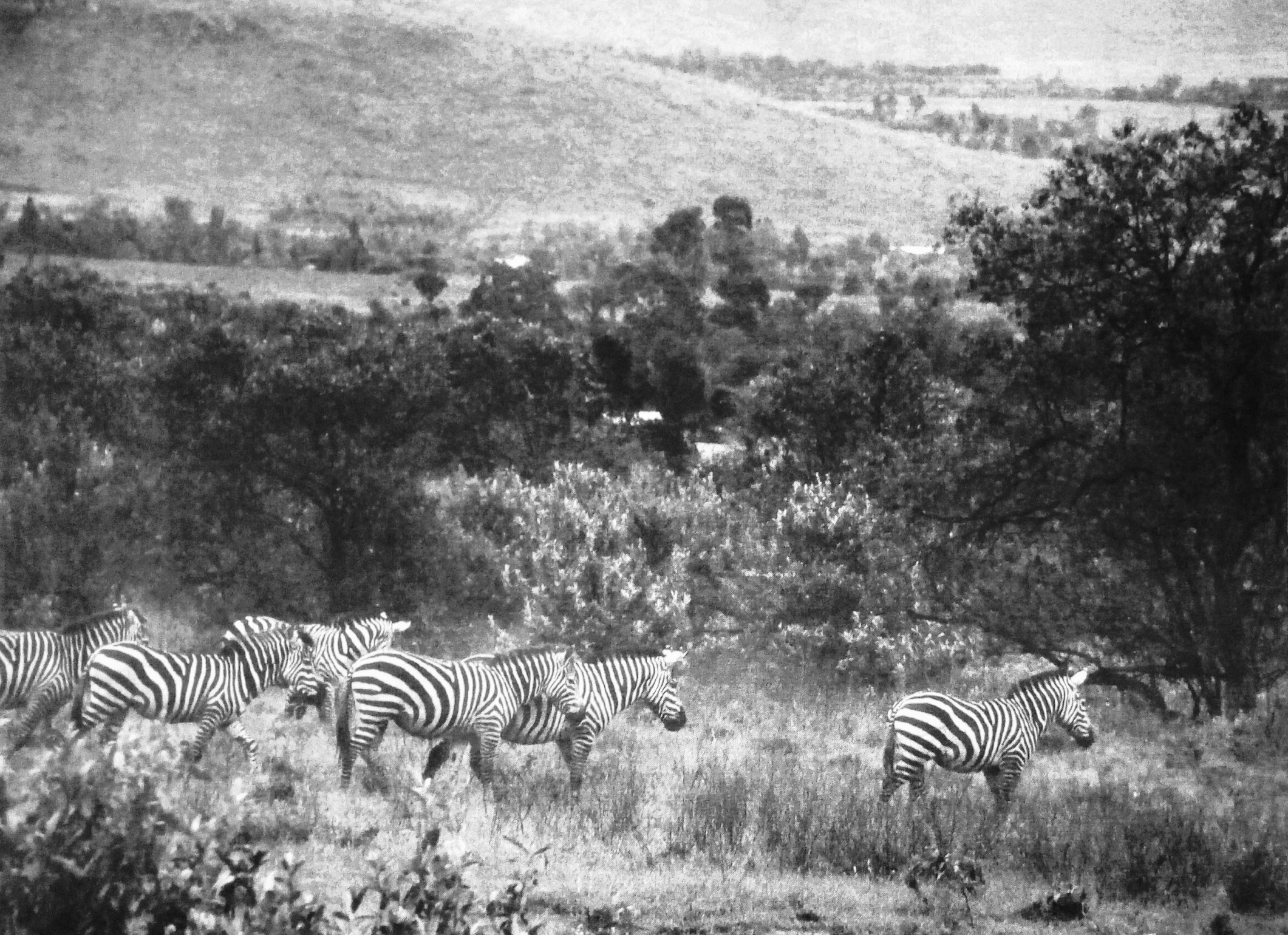
a) Name the tourist attraction found in the
i) foreground
ii) middle ground
iii) background
b) Identify any three characteristics of the tourist attraction foundation in the middle ground
c) Draw a landscape sketch of the area shown on the photo and on it mark and name:
i) the three tourist attractions mentioned in (a) above
ii) water body
iii) two settlements
d) i) Describe the factors favoring the development of tourism in the area shown in the photo.
ii) Giving evidence from the photograph, name any one area in East Africa where the photograph could have been taken
3. COMPULSORY FIELDWORK QUESTION
Answer all parts of this question
For any one field work study you have conducted either as an individual or group:
a) State the:
i) topic and
ii) objectives
of the study
b) Draw a sketch map of the area studied and on it, mark and name any;
i) two physical features
ii) three human activities
c) Describe the relationship between physical features and human activities
SECTION B: EAST AFRICA
Answer only one question from this section
4. Study Table 1 below, showing Annual Limestone production in Uganda between 2010 and 2015, and answer the questions that follow,
Table 1
|
Year |
Quantity (in tonnes) |
|
2010 2011 2012 2013 2014 2015 |
634,674 932,349 936,264 922,372 1,090,240 979,660 |
Adapted: Ministry of Energy and Mineral Development and UBOS Statistics 2015 (page 204) and 2016 (page 205)
a) Draw a bar-graph to show the annual limestone production in Uganda
b) Describe the trend of annual limestone production in Uganda between 2010 and 2015
c) Explain the factors that have led to the trend in limestone production described in (b) above.
d) Suggest measures that should be taken to improve the mining industry in Uganda.
5.a) With the aid of diagrams, distinguish between a fringing reef and a barrier coral reef.
b) Explain the factors that have led to the growth of coral reefs along the coast of East Africa
c) What is the value of having coral reefs along the coast of East Africa?
d) Outline the problems caused by the presence of coral reefs to the people of East Africa.
6.a) Draw a map of East Africa and on it mark and label:
i) any one densely populated area in each country
ii) two sparsely populated areas
iii) River Nile
b) Describe the conditions that have led to:
i) dense population
ii) sparse population
c) Explain the problems faced by people living in the densely populated areas of East Africa
d) Giving examples, outline the steps being taken to control the effects of high population density in East Africa.
7. Study Fig 1, map of East Africa provided and answer the questions that follow
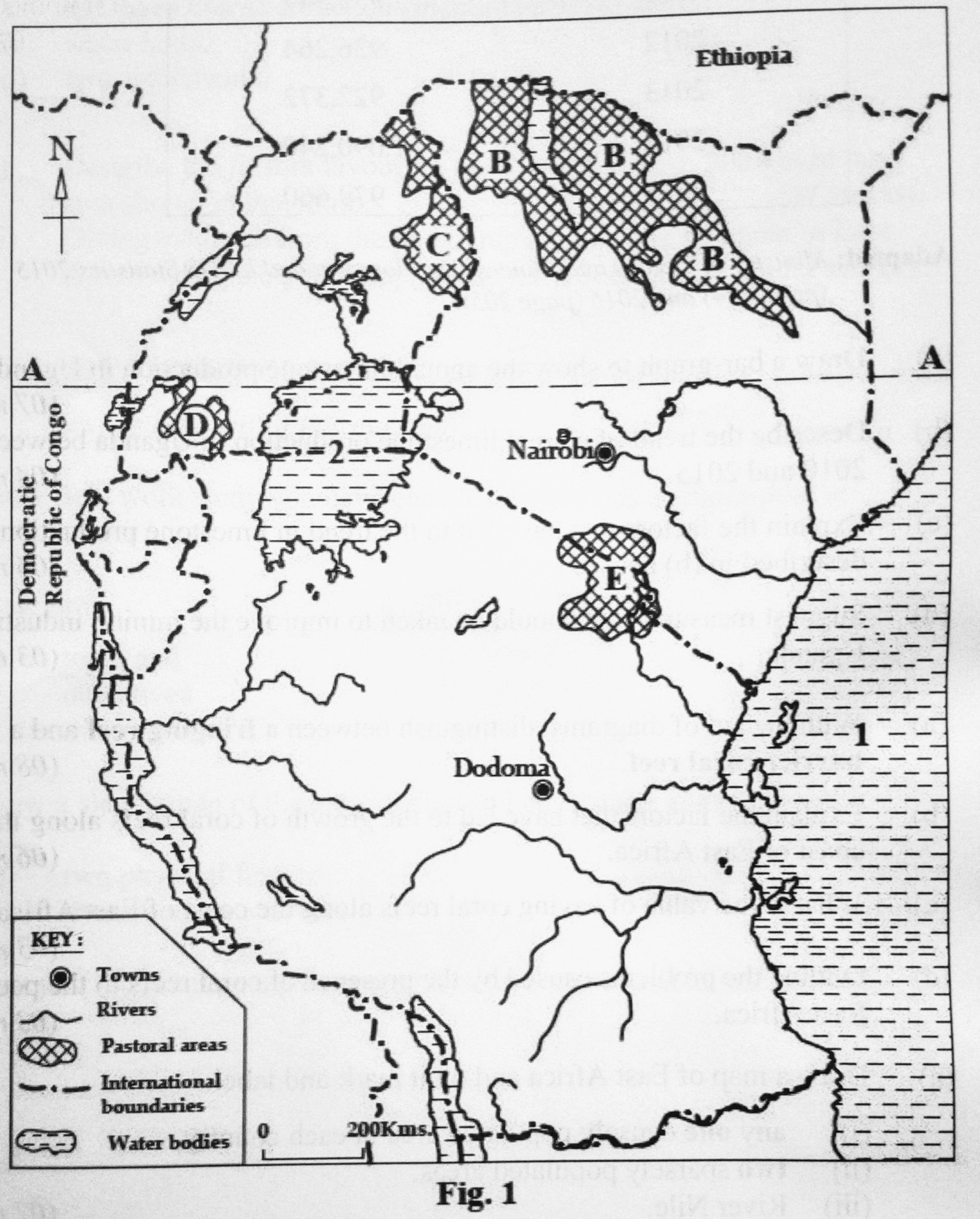
a) Name the:
i) latitude marked A
ii) pastoral tribes marked B, C, D and E
iii) water bodies marked 1 and 2
b) With reference to any one pastoral tribe in East Africa, describe the characteristics of nomadic pastoralism.
c) Explain the contribution of pastoralism to the development of East Africa.
d) Outline the steps being taken to improve the way of life of nomadic pastoralists in East Africa.
END