1. Which one of the following factors explains the migration of people from Kabale district?
A. Government policy
B. Land shortage
C. Scarcity of building materials
D. Rugged terrain
2. Material carried along by a glacier is called
A. moraine
B. alluvium
C. scree
D. silt
3. The vertical section through the soil is called the soil
A. texture
B. structure
C. catena
D. profile
4. Which type of climate in East Africa has the following characteristics?
i) Heavy rainfall all year round
ii) High relative humidity
iii) Small annual temperature range.
5. The major problem faced by the pastoral nomads inNorth-Eastern Kenya is
A. diseases
B. poor soils
C. wild animals
D. low rainfall
6. Cement industries are located near the coast of East Africa mainly because of the
A. existence of a ready market
B. presence of skilled labor
C. nearness to raw materials
D. availability of cheap transport
7. Which of the following tree species is found in the high altitude areas of East Africa?
A. Mahogany
B. Cedar
C. Mvule
D. Palm tree
8. The major advantage of using containers at Mombasa port is to reduce
A. theft of valuable goods
B. damage of fragile goods
C. accidents among workers
D. loading and offloading time
9. The fish preservation method commonly used in East Africa is
A. smoking
B. freezing
C. salting
D. sun drying
10. Which one of the following towns in East Africa developed due to mining?
A. Mbale
B. Tabora
C. Nairobi
D. Mwadui
11. The major problem facing the tourism industry in East Africa is
A. poaching
B. insecurity
C. remoteness
D. diseases
12. Which one of the following goods is exported using air transport?
A. Timber
B. Coffee
C. Cotton
D. Flowers
13. North-Eastern Uganda is sparsely populated mainly because of
A. unreliable rainfall
B. sandy soils
C. remoteness
D. insecurity
14. Which of the following lakes in East Africa was formed due to deposition?
A. Victoria
B. Tanganyika
C. Nabugabo
D. Magadi
15. The temperatures of Jinja are higher than those of Kabale due to differences in
A. humidity
B. cloud cover
C. latitude
D. altitude
16. The major factor for the decline in cotton production in East Africa is
A. reduction in soil fertility
B. competition from synthetic fibres
C. changes in prices
D. infestation by pests and diseases
17. In which of the following industries is tannin used as a raw material?
A. Leather processing
B. Textile manufacturing
C. Soap making
D. Beer brewing
18. Which one of the following tree species is a hardwood?
A. Pine
B. Cypress
C. Cedar
E. Ebony
19. The major factor for the development of fish farming in East Africa is to
A. earn income for farmers
B. increase food production
C. promote fish export
D. reduce overfishing
20. The tourism industry in Uganda has been improved mainly through
A. introduction of new wildlife species
B. training more game wardens
C. creation of new national parks
D. advertising the tourist attractions
21. The main reason why the Lake Victoria region of East Africa is densely populated is the
A. cool climate conditions
B. presence of fertile soils
C. good transport network
D. presence of industries
22. Sisal growing is mainly carries out along the coast of East Africa because of the
A. unreliable rainfall
B. availability of land
C. abundant sunshine
D. gently sloping relief
23. The major problem limiting large scale fishing on Lake Victoria is the
A. irregular shape of the coast line
B. presence of the water hyacinth
C. threat of crocodiles
D. shallow waters
24. Which of the following minerals is formed as a result of evaporation?
A. Gypsum
B. Diamonds
C. Soda ash
D. Cobalt
25. The major export commodity from Zanzibar to Europe is
A. timber
B. cloves
C. copper
D. frozen fish
26. Which one of the following is a volcanic mountain in East Africa?
A. Usambara
B. Rwenzori
C. Uluguru
D. Muhavura
27. Soils in tropical rain forests of East Africa are heavily leached mainly
A. heavy rainfall
B. gentle slopes
C. thick vegetation cover
D. high human interference
28. The main problem affecting the mining of iron ore in the southern highlands of Tanzania is
A. fluctuating prices
B. shortage of skilled labor
C. remoteness
D. low quality ores
29. Which one of the following is a characteristic of shifting cultivation?
A. Use of scientific methods
B. Crops grown are for sale
C. Settlements are permanent
D. Crops are grown on small holdings
30. A plunge pool exists along a river profile where there is a
A. delta
B. leeve
C. waterfall
D. meander
PART II
MAPWORK, PHOTOGRAPH INTERPRETATION, FIELD WORK AND EAST AFRICA
Answer four questions from Part II, including Questions 1,2 and 3 which are compulsory.
SECTION A
1. COMPULSORY QUESTION : MAPWORK
Answer all parts of this question.
Study the EAST AFRICA 1:50,000 (UGANDA) ALOI Map extract, part of Sheet 33/1, Series Y732, Edition 1 – U.S.D and answer the questions that follow.
a) i) Name the man-made feature found at grid-reference 219506.
ii) State the grid reference of the bridge on River Moroto.
b) Determine the bearing of Lira-Soroti level – crossing (Grid ref 110487) from the Mission East of Anyanga (grid ref. 220580).
c) Draw a cross section from grid ref 097560 and 171550 and on it mark and name:
i) Ongom River/ Kai river,
ii) a hill,
iii) settlements,
iv) county boundary
v) all weather loose-surface road.
d) Describe the:
i) relief of the area,
ii) relationship between relief and drainage.
2. COMPULSORY PHOTOGRAPH INTERPRETATION QUESTION
Answer all parts of this question
Study the photograph provided below and answer the questions that follow
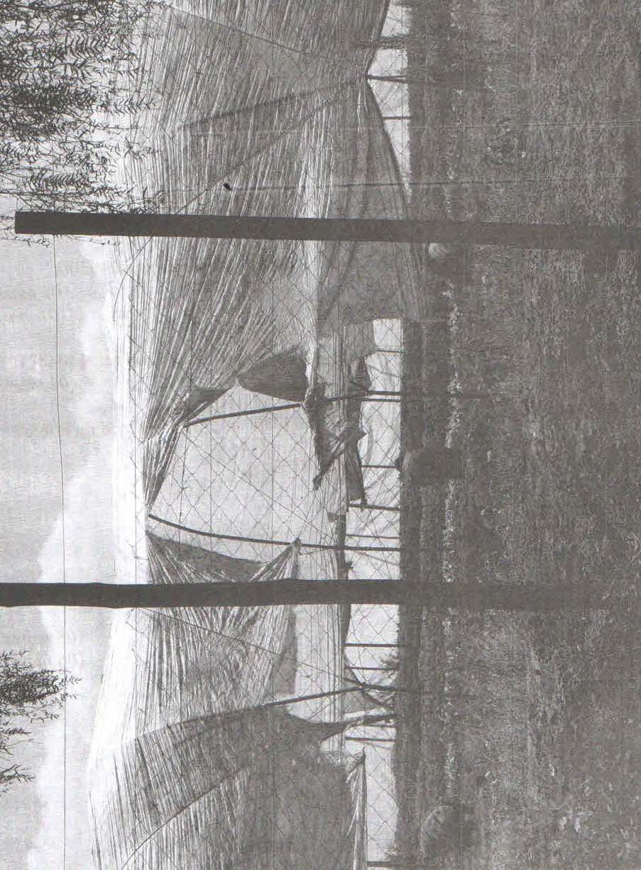
a) Draw a landscape sketch of the area shown on the photograph and on it mark and label :
i) the area under crops,
ii) any three types of materials used to construct the structure in the photograph,
iii) the workers
b) Identify the method used to grow crops in the area shown on the photograph.
c) Outline the:
i) advantages,
ii) disadvantages
of using the method identified in (b) above.
d) Suggest one area in East Africa where this photograph could have been taken.
3. COMPULSORY FIELD WORK QUESTION
Answer all parts of this question
For any one fieldwork study you have conducted:
a) State the :
i) topic
ii) objectives
of the field study.
b) Explain how you used any two of the following methods during the study:
i) observation
ii) recording
iii) measurement
iv) interviewing
c) Mention the follow-up activities that you carried out after the field study.
d) Outline the problems you faced during the field study
SECTION B: EAST AFRICA
4.a) Draw a sketch map of East Africa and on it, mark and name:
i) Mangroove forests
ii) Montane forests
iii) Miombo woodlands
iv) Lake Turkana
v) The Equator
b) Describe the characteristics of any two vegetation types in (a) above.
c) Outline the economic activities taking place in the forested areas of East Africa.
d) What are the effects of the economic activities in (c) above on the environment?
5. Study the table below showing the imports of goods and services by value (in million US dollars) from Uganda and Kenya; and answer the questions that follow.
|
Country |
2006 |
2007 |
2008 |
2009 |
2010 |
|
Uganda |
2829 |
3581 |
4618 |
5557 |
5833 |
|
Kenya |
8514 |
10,268 |
12,719 |
11,196 |
12,192 |
Adopted: African Development Indicators 2012/13
a) Draw a line graph to show the value of imports between 2006 and 2010 for Uganda and Kenya.
b) Describe the trend of imports between 2006 and 2010 for:
i) Uganda
ii) Kenya
c) Explain the contribution of international trade to the development of East Africa.
d) Outline the factors limiting trade among East African countries.
6 a) Distinguish between rural and urban population.
b) Explain the factors that have influenced rural population distribution in East Africa.
c) Outline the effects of a large rural population on the environment in East Africa.
d) State the measures being taken to improve the quality of life of the rural population in East Africa.
7. Study figure 1, map of East Africa provided, and answer the questions that follow:
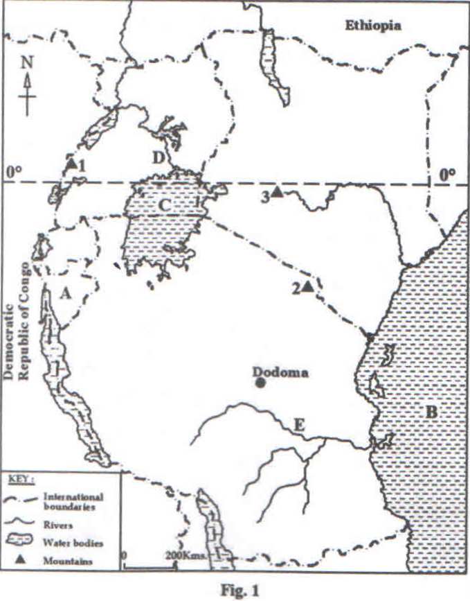
a) Name the:
i) country marked A,
ii) water bodies marked B and C
iii) rivers marked D and E,
iv) glaciated mountains marked 1,2 and 3
b) Name any two erosional glacial features found in any of the areas marked 1, 2 and 3 in (a) (iv) above.
c) Describe the process leading to the formation of any of the erosional features named in (b) above.
d) Outline the problems faced by the people living in glaciated areas of East Africa.