There are 30 compulsory questions. Each question carries one mark. Answers to this part must be written in the answer booklet provided.
1. Migration from Kigezi are mainly a result of
A. unemployment
B. land shortage
C. soil erosion
D. pests and diseases
2. The major problem facing railway transport in East Africa is
A. competition with road transport
B. high fuel costs
C. inadequate capital
D. limited skilled labor
3. Which one of the following rocks is used in the construction of tarmac roads?
A. Laterite
B. Sandstone
C. Shale
D. Granite
4. The weight of air pushing on the earth’s surface is called
A. insolation
B. atmospheric pressure
C. precipitation
D. relative humidity.
5. The major reason for wildlife conservation in East Africa is
A. promoting good international relationship
B. advertising goods and services abroad
C. employing the people
D. earning foreign exchange
6. Nomadic pastoralism is practiced in the Masai land mainly because of
A. low quality pastures
B. unreliable rainfall
C. pests and diseases
D. large tracts of land
7. The Usambara mountain was formed by a process of
A. warping
B. erosion
C. faulting
D. vulcanicity
8. Which one of the following crops grows well in areas of low rainfall?
A. Rice
B. Sisal
C. Tea
D. Pyrethrum
9. The major factor favoring the growth of Bamboo forests in East Africa is
A. altitude
B. soils
C. drainage
D. climate
10. Which one of the following is true about horticulture farming?
A. Uses plenty of machinery
B. Needs plenty of cheap labor
C. Grown on large pieces of land
D. Needs quick means of transport
11. The major tourist attraction in East Africa is the
A. warm, sunny climate
B. beautiful mountain scenery
C. abundant wildlife
D. historical sites
12. Which one of the following minerals in East Africa is used in the manufacture of fertilizers?
A. Soda ash
B. Coal
C. Phosphates
D. Flouspars
13. The Nandi escarpments in Kenya was formed by the process of
A. vulcanicity
B. faulting
C. folding
D. warping.
14. Industrialization in Uganda can be best achieved by
A. encouraging foreign investment
B. improving the transport network
C. training industrial workers
D. establishing industrial parks
15. The major problem faced by fish farmers in Uganda is
A. shortage of capital
B. limited market
C. shortage of skilled labor
D. limited land to construct fish ponds
16. Which one of the following towns is located along the coast of East Africa?
A. Musoma
B. Lamu
C. Bukoba
D. Mwanza
17. The major factor limiting commercial agricultural production in Uganda is
A. poor transport network
B. pests and diseases
C. inadequate rainfall
D. limited capital
18. Which one of the following coastal landforms is formed by wace deposition?
A. Cliff
B. Beach
C. Stack
D. Arch
19. Fish exports from Uganda are transported by
A. road
B. rail
C. air
D. water
20. The major problem faced by people living on the slopes of Mt. Elgon is
A. cold temperatures
B. shortage of wood fuel
C. occurrence of landslides
D. decline in crop yields.
21. Which one of the following industries in East Africa is located near the source of raw materials?
A. Steel rolling
B. Sugar processing
C. Grain milling
D. Textile manufacture
22. The low rainfall received in the rift valley areas of East Africa is a result of
A. flat relief
B. scanty vegetation
C. human activities
D. rain shadow effect
23. Which of the following factors has caused rapid population increase in Uganda?
A. High birth rates
B. Political stability
C. Improved medical services
D. Increased food production
24. The traditional fishing method used in the swampy areas of East Africa is
A. beach seining
B. trawling
C. spearing
D. long lining
25. The process by which minerals are transported to the lower layers of the soil profiles is known as
A. leaching
B. erosion
C. capillarity
D. weathering
26. Dredging method is used in the mining of
A. copper
B. soda ash
C. petroleum
D. limestone
27. Nairobi city is mainly important as a centre for
A. communication
B. tourism activity
C. commerce
D. cultural activities
28. The type of climate which is characterized by alternating wet and dry season is
A. semi desert
B. montane
C. equatorial
D. tropical savannah
29. Which fish landing site is found on Lake Tanganyika?
A. Butiaba
B. Mwanza
C. Kisumu
D. Kigoma
30. The extensive loss of forest vegetation in East Africa has been mainly caused by
A. mining and quarrying
B. agricultural activities
C. brick making
D. charcoal burning.
PART II
MAP WORK, PHOTOGRAPH INTERPRETATION, FIELD WORK AND EAST AFRICA
Answer four questions from Part II, including Questions 1,2, and 3 which are compulsory.
SECTION A
1. COMPULSORY QUESTION: MAP WORK
Answer all parts of this question.
Study the 1:50,000 (UGANDA) Nyareweyo Map extract, part of sheet 48/4, Series Y732, Edition 1-U.S.D and answer the questions that follow:
a) i) State the grid reference of the borehole south Kigudura.
ii) Name the relief feature found at the grid reference 174 328.
b) What is the bearing of Luhunga trignometrical station. (Grid reference 081358) from Kichobino grid reference 164262?
c) Draw a cross-section from grid reference 090350 and 150350 and on it mark and name:
i) a dry weatherroad
ii) river Mugoro
iii) country boundary
iv) swamp
v) forests
d) Describe the:
i) relief of the area
ii) relationship between relief and vegetation of the area shown on the map.
2. COMPULSORY PHOTOGRAPH INTERPRETATION QUESTION
Answer all parts of this question
Study the photograph provided below and answers the questions that follow;
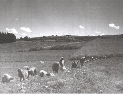
a) Identify the economic activity taking place in the foreground.
b) Describe the factors that have favored the economic activity identified in (a) above.
c) Draw a landscape sketch of the area shown on the photograph and on it mark and name:
i) any three relief features
ii) any two vegetation types
iii) settlements
d) Giving reasons for your answer, suggest an area in East Africa where this photograph ought to have been taken.
3. Compulsory field work question
Answer all parts of this question
For any one fieldwork study you have conducted:
a) i) State the topic of study
ii) Outline the objectives of the study
b) Mention the preparations that you made before the field study.
c) Draw a sketch map of the area studied and on it mark and name:
i) relief features
ii) land use activities
d) Describe the relationship between relief features and land use activities in the area studied.
SECTION B: EAST AFRICA
4. a) Draw a sketch map of East Africa and on it, mark and name
i) the East African Rift valley,
ii) Lakes: Victoria and Malawi,
iii) any three mountains with glacial features
b) Name any two erosional glacial features found on the mountains marked in (a) (iii) above.
c) Describe the process that led to the formation of any one of the glacial features named in (b) above.
d) Explain the importance of glaciations to the people of East Africa.
5. Study the table below, showing the exports of goods and services by value from Uganda and Tanzania and answer the questions that follow
|
Country |
2006 |
2007 |
2008 |
2009 |
2010 |
|
Uganda |
1,524 |
1,993 |
3,506 |
3,753 |
4,087 |
|
Tanzania |
3,233 |
4,079 |
5,208 |
4,963 |
5,975 |
Adopted: African Development Indicators 2012/13
a) Draw a line graph to show the value of exports for Uganda and Tanzania between 2006 and 2010
b) Describe the trend of exports between 2006-2010 for:
i) Uganda
ii) Tanzania
c) Explain the factors which have influenced export trade in any one country given in the table.
d) Outline the contribution of international trade to the development of East Africa
6. a) Distinguish between population density and population distribution.
b) Name any one area in East Africa with :
i) high population density
ii) low population density
c) Explain the factors responsible for the high population density in one of the areas named in (b) (i) above
d) i) Outline the problems faced by people living in areas of high population density
ii) Suggest measures that should be taken to solve the problems mentioned in (d) (i) above.
7. Study figure 1, sketch map of East Africa provided and answer the questions that follow: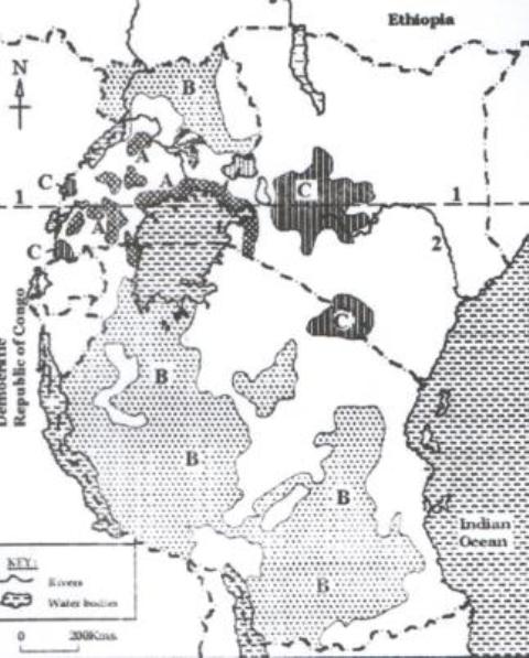
a) Name the
i) vegetation types marked A, B and C
ii) latitude marked 1
iii) water body marked 2
b) Describe the characteristics of any one vegetation type marked in (a) (i) above
c) Explain the importance of any one type of vegetation marked in (a) (i) above
d) Outline the problems faced by the people living in the area identified in (c) above.
END