PART 1
These are Compulsory questions. Each carries one mark
- The coastal areas of East Africa are densely populated mainly because of
- heavy rainfall
- fertile soils
- stable political climate
- improved transport system
- Which of the following is a physical weathering process?
- Oxidation
- Exfoliation
- Hydrolysis
- Carbonation
- Which one of the following is a block mountain?
- Moroto
- Kilimanjaro
- Muhabura
- Usambara
- Mwea Tebere irrigation scheme draws its waters from rivers
- Ruaha and Kilombero
- Pangani and Wami
- Thiba and Nyamindi
- Nzoia and Yala
- Which one of the following industries was attracted to Jinja due to the availability of hydro-electric power?
- Beer brewing
- Copper smelting
- Sugar refining
- Cotton ginning
- The greatest problem affecting the fishing industry in East Africa is
- limited fish species
- presence of the water hyacinth
- Sugar refining
- Cotton ginning
- The major advantage of constructing the Mombasa-Eldoret petroleum pipeline is to reduce
- road damage by fuel tankers
- fuel spillage
- accidents by fuel tankers
- fuel distribution costs
- Which one of the following is the major factor responsible for the increase in the population of East Africa?
- Polygamous marriages
- Low death rates
- High fertility rates
- Improved medical facilities.
- Which of the following areas in East Africa experiences a high diurnal range of temperature?
- South Western Kenya
- North Eastern Kenya
- South Western Uganda
- North Western Uganda
- Equatorial forests in East Africa have been mainly cleared for
- settlement
- industries
- road construction
- agriculture
- Which of the following measures has been mainly used to promote tourism in Uganda?
- Advertisement of tourism
- Encouraging local tourism
- Training game wardens
- Improving accommodation facilities
- The flood plains of rivers in East Africa are mainly used for
- animal grazing
- crop cultivation
- human settlement
- wildlife conservation
- Which of the following types of soils is commonly found in swampy areas?
- Sandy soils
- Loam soils
- Clay soils
- Lateritic soils
- In Uganda, temperature inversion is common in
- Kotido
- Bundibugyo
- Mpigi
- Kabale
- The mode of transport which has greatly contributed to the development of the mining sector in East Africa is
- railway
- road
- water
- air
- Which one of the following fish landing sites is found on Kazinga channel?
- Kasenyi
- Katunguru
- Rwenshama
- Wanseko
- Which one of the following is a commercial method of fishing used on Lake Kyoga?
- Use of baskets
- Use of hooks
- Gill netting
- Trawling
- Which one of the following industries in East Africa is located near the source of the raw materials?
- Textile manufacturing
- Steel rolling
- Oil refining
- Cement works
- The wet bulb and dry bulb thermometers are used to measure
- temperature
- humidity
- pressure
- wind
- Which one of the following activities has greatly led to the destruction of Savannah vegetation in East Africa?
- Cultivation
- Pastoralism
- Lumbering
- Wildlife conservation
- Which of the following factors has accelerated soil leaching in East Africa?
- Steep slopes
- High altitude
- Heavy rainfall
- High temperature
- Which one of the following minerals is the major foreign exchange earner in East Africa?
- Soda ash
- Cobalt
- Gold
- Diamonds
- Ranching in East Africa has been improved mainly through
- vaccination
- cross breeding
- digging valley dams
- rotational grazing
- Which one of the following crops requires heavy rainfall which is well distributed throughout the year?
- Sugarcane
- Cotton
- Sisal
- Tobacco
- Which one of the following coastal landforms has been formed by deposition?
- Cliff
- Arch
- Beach
- Stack
- Marine life conservation in East Africa is being carried out in
- Tsavo national park
- Malindi national park
- Serengeti national park
- Kidepo national park
- Which one of the following lakes was formed due to lava damming?
- Katwe
- Edward
- Mutanda
- Albert
- Which one of the following crops in East Africa is grown in green houses?
- Flowers
- Apples
- Citrus fruits
- Vanilla
- Export commodities from Uganda are mainly
- foodstuffs
- raw materials
- fuels
- manufactured goods
- Which one of the following is a major problem facing the salt mining industry at Lake Katwe?
- Limited skilled labor
- Poor roads
- Narrow local market
- Limited capital
PART II
MAPWORK, PHOTOGRAPH INTERPRETATION, FIELD WORK AND EAST AFRICA
Answer four questions from part II, including questions 1,2 and 3 which are compulsory.
SECTION A
- COMPULSORY QUESTION : MAPWORK
Answer all parts of this question.
Study the 1:50,000 UGANDA: LAKE NAKIVALI map extract, part of Sheet 86/4 Series Y732, Edition 4-U.S.D and answer the questions that follow:
- i) State the grid reference of the borehole north of Nyamiyongo
- Identify the man-made feature found at grid reference 611166.
- Measure and state the distance (in Kilometres) of the dry weather road from Musirira road junction (grid reference 610082) to Ijumuriro road junction (grid reference 736109).
- Draw a cross-section along a long Northing 02 between grid references 600020 and 670020 and on it, mark and name:
- gentle slope
- any two rivers
- dry weather road broad valley
- settlements
- Describe the relationship between relief and communication in the area shown on the map.
2. COMPULSORY PHOTOGRAPH INTERPRETATION QUESTION
Study the photograph provided below and answer the questions that follow:
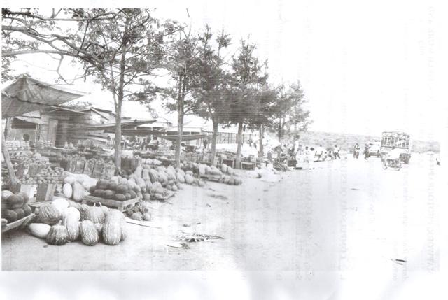
- Identify the:
- economic activity taking placein the photograph
- types of crops seen in the photograph
- Describe the factors that have favored the economic activity identified in (a) (i) above.
- Explain the problems faced by the people carrying out the activity shown in the photograph. Give reasons for your answer.
- Giving reasons for your answer, suggest one area in East Africa wher this photograph could have been taken.
3. COMPULSORY FIELDWORK QUESTION
Answer all partsof this question
For any one field work study you have conducted:
- i) State the topic of the study,
ii) Outline the objectives of the study - Describe how any two of the following methods were used to collect information from the field during the study:
- observation
- recording
- measurement
- Outline the disadvantages of using the methods chosen in (b) above.
- What follow-up activities did you carry out after the fieldwork study?
SECTION B: EAST AFRICA
Answer only one question from this section
4. Study the table below showing the population of three East African countries and answer the questions that follow.
|
Country |
Land Area (‘000km2) |
Total Population in Millions (2012) |
Urban Population as a percentage of Total Population (2012) |
|
Uganda Kenya Tanzania |
241.6 580.4 947.3 |
36.3 43.2 47.8 |
16 24 27 |
Adapted from: World Development Indicators, 2014. The World Bank, Washington D.C . Pp.14 and 16
- Calculate the:
i) number of people living in urban centers for each country.
ii) total population living in urban areas of East Africa. - Draw a pie-chart to show the proportion of the urban population for the three East African countries.
- i) Name any one urban centre in each of the three East African countries.
ii) Explain the causes of urbanization in East Africa - Outline the problems faced by people living in the urban areas of East Africa.
- a) Differentiate between weather and climate.
b) Describe how rainfall is measured at a weather station.
c) Explain the factors which influence rainfall distribution in East Africa.
d) Outline the problems faced by people living in areas that receive low rainfall in East Africa.
6. a) Draw a sketch map of East Africa and on it, mark and name:
- tropical rain forests
- Miombo woodlands
- semi-desert vegetation
- the Indian ocean
- the Equator
b) Describe the characteristics of tropical rain forests
c) Explain the conditions which have influenced the distribution of tropical rain forests in East Africa.
d) Outline the benefits of tropical rain forests in East Africa.
7. Study the map of East Africa provided below and answer the questions that follow.
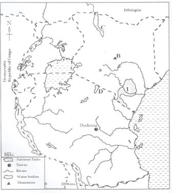
- Name the:
- mountains marked A and B
- lakes marked C and D
- national parks marked 1 and 2
- Mention any two:
- tourist attractions found in East Africa
- countries where tourists come from.
- Explain the benefits of the tourist industry to the people of East Africa.
- Outline the problems faced by the tourist industry in East Africa.